Satellite-Based Advisory Service Launched for Deep Sea Fishermen
- News
- 1.8K
The Indian National Centre for Ocean Information Services (INCOIS) and Airport Authority of India on Wednesday launched a new system that expands the scope for disseminating alerts and other messages to fishermen who go for multi-day fishing and other such activities deep inside the seas.
At present, fishermen get advisories, forecasts and early warnings through a wide range of dissemination mechanisms such as Potential Fishing Zones (PFZ) advisories, ocean state forecasts, high wave alerts, tsunami and storm surge early warning services. But these messages can be transmitted only up to a distance of 10 to 12 km from the coast. Such information needs to be conveyed even to those venturing into the sea beyond 50 nautical miles (90 km) and further.

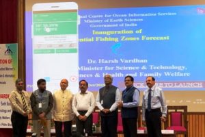
The new service, formally launched by the minister for science and technology and earth sciences Dr. Harsh Vardhan, will fill this gap.
The gap in communication was severely felt during the Ockhi cyclone of November-December 2017 when fishermen who had gone out for deep-sea fishing before the onset of the cyclone could not be informed of the impending storm. This resulted in a loss of life, serious injuries to those rescued and severe damages to fishing boats and fishing gear.
The new system is designed to overcome the problem. It consists of a specially designed device and a mobile application. It works by using the communication opportunity provided by GAGAN (GPS-Aided Geo Augmented Navigation) satellite system of the Indian Space Research Organization (ISRO) and Airports Authority of India. GAGAN consists of three geosynchronous satellites – GSAT-8, GSAT-10 and GSAT-15 and its footprints cover the entire Indian Ocean round the clock.
Alerts and other messages would be sent through GAGAN and the device would receive and transfer it to a mobile phone through blue tooth communication. The mobile application would decode and display the information. It is enabled to do so in nine languages. The technology for the device has been transferred to a Bengaluru-based company, Acord. The device has been named GEMINI (GAGAN Enabled Mariner’s Instrument for Navigation and Information).
Dr. Harsh Vardhan launched the system in the presence of Dr. Madhavan Rajeevan (Secretary, Ministry of Earth Sciences), Dr. Satheesh C.Shenoi (Director, INCOIS) and other senior officials.
The minister also launched an improved version of the Potential Fishing Zone (PFZ) forecasts developed by INCOIS. The new version will provide advisories for three days in advance. The forecasts are generated using the modern tools of numerical models and thus are expected to help provide the advisories even when skies are overcast. (ISW)
If you liked this article, then please subscribe to our YouTube Channel for the latest Science & Tech news. You can also find us on Twitter & Facebook.


